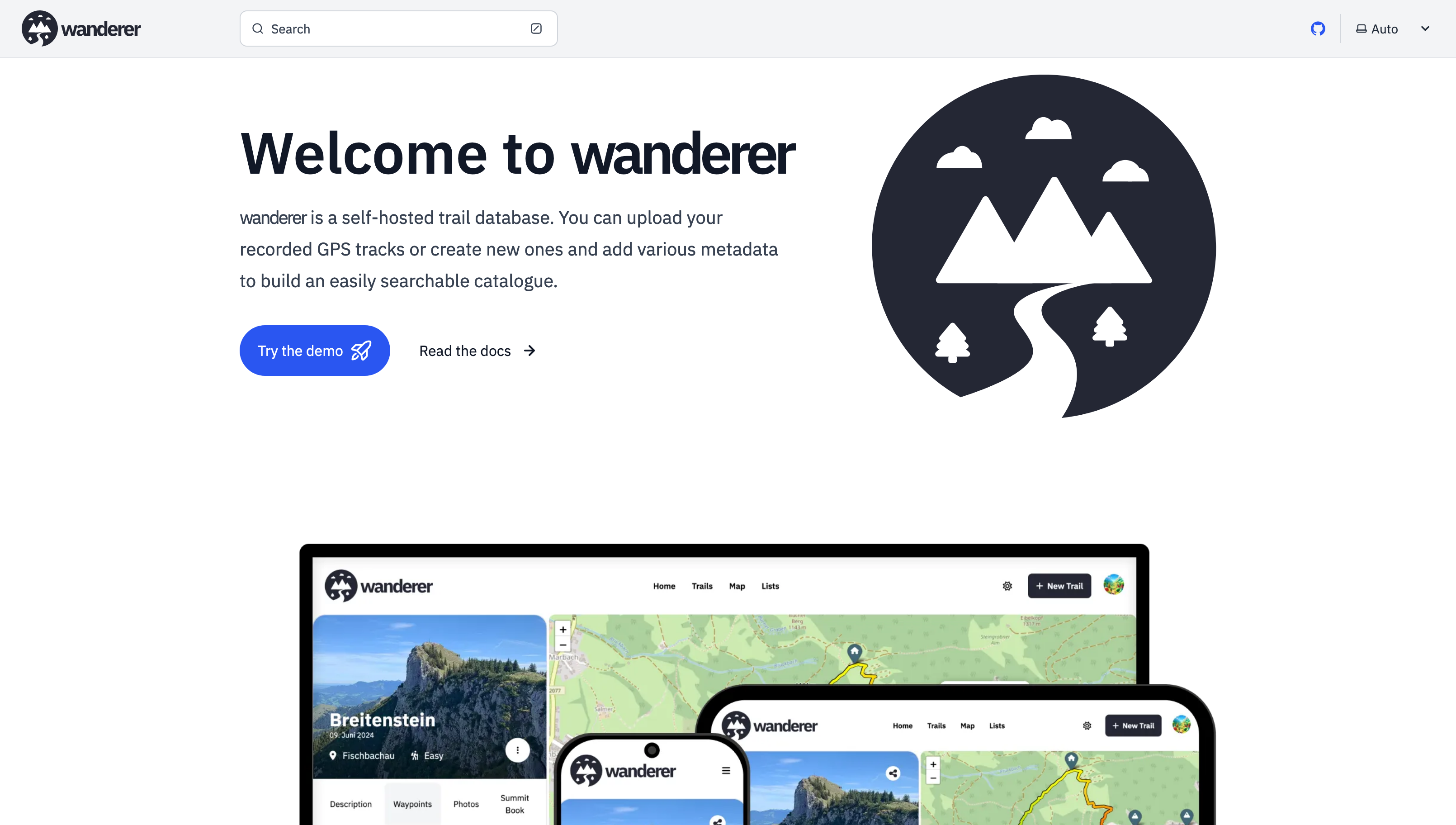
it’s been a while since my last post. Since then - with the help of this awesome community - I have added multiple new features and fixed a lot of bugs.
Most importantly there is now a working demo alongside a shiny new landing page.
And here are some more fun features I added since then:
Trail drawing: in addition to uploading you GPX, TCX or KML files, you can now also simply draw a trail by defining multiple waypoints. The route between them will be calculated automatically.
Sharing trails: simple and straightforward - you can share your trails with other users and let them view or edit.
Printing trails: there is now a dedicated print view. Plan your adventure digitally and then take it with you on paper.
wanderer is now available in 8 different languages (thanks to translators from the community). If you would like to contribute a translation you can do so here.
You can now bulk upload multiple trails at once simply by putting them in a dedicated auto-upload folder
And much more. I’d be happy if you give it a try in case you haven’t yet.
Is there any support for heart rate data inclusion on recorded trails? Maybe I’m really looking for a different app to keep track of that sort of thing. I haven’t yet started monitoring heart rate on my bike rides but I’m considering options for tracking now.
I host wanderer and really enjoy it for what it is. I’m only supporting my wife and I but am considering opening it up to my friend group.
Ah, ok, so I can export my OsmAnd paths, import into this and then remind myself of where I went on holiday / almost fell of a cliff / got lost driving / etc ?
I have a bunch of tracks I’ve saved over the years… hmm… maybe this is what I should be using
Looks like what I wanted! However, it doesn’t seem to let me export to a supported format for Wanderer (only kmz?), could you confirm @get_flomped@lemmy.world ?
Open Tracks allows exporting in either KMZ (default), KML or GPX format. Go to Settings, tap on “Import and Export” and there look, towards the end, for the entry “Export/sharing file format”.
If you guys like hiking and stuff, there’s this cool open source app called trail sense on f-droid and it’s just so much feature packed…
I don’t hike, so I only use it for it’s pedometer capabilities and a hypothetical situation where “I might get really lost” but the amount of features it has for hiking and survival is crazy and so I think deserves to be more known.
Yeah, I have trail sense installed - but everytime I’m out and about I just can’t work out how to use the myriad functions it has (like how high something is, etc)…
How well fitted would this be for a Google maps timeline replacement?
I see you mention we need to upload the files which maybe could be obtained from an app like https://github.com/mendhak/gpslogger
I already had a flow to have them on my server with syncthing, so I could easily use your api to process them.
The thing would be to have each trail be marked as each day and have a way of showing them nicely (I haven’t tested everything in the demo hehe).
Is there a plan to be able to process any GPS standard to automatically generate the trails?
I’m currently using traccar, but it looks more like a fleet management than something to remember where you’ve been.
Just tried it and seems too complicated haha.
With traccar I just had to deploy a single service and use either the official app or previously gpslogger sending the data to an endpoint.
With owntracks the main documentation seems to be deploy it into the base system, docker is kind of hidden.
And with docker you need to deploy at least 3 services: recorder, Mosquitto, and the front end.
The app doesn’t tell you what’s expected to be filled into the fields to connect to the backend. I tried with https but haven’t been able to make it work.
To be fair, this has been just today. But as long as a service has a docker compose I’ve always been able to deploy it in less than 10 minutes, and the rest of the day is just customizing the service.
Looks cool. I have it up and running with the docker compose provided. Every time I try to create a user it says “Error creating user”, and the logs say [ERROR] [23:30:00]: Login failed. Unable to obtain cookie.
Edit: I got it working, just had to updated some of the network stuff in the docker compose. The networking in Portainer is a bit “complex”.
I’m able to save a trail without any photos, but if I try to add a photo it lets me select the photo, but saving the trail gives a toast notification in the bottom right that says “Error saving trail.” The web, db, and search logs don’t show any errors.
Mine was having some weird problem with docker, I think it must be a docker bug. Basically it put the Wanderer stuff at the very bottom of the routes (running “sudo route” on Debian lists the routes). The last entry in the routes table needs to be eth0 or the equivalent so that stuff can loop back to the beginning of the list. At least that’s my understanding.
So anyway, to get around that bug/limitation I had to create a static docker network which I called “wanderer-static” using docker network create --attachable -d bridge --subnet 172.28.0.0/16 --gateway 172.28.0.1 wanderer-static. Choose a subnet that’s not being used already.
Then in the docker compose file, point everything at that network by:
Removing
 networks:
   wanderer:
     driver: bridge
Adding
networks:
  wanderer-static:
    external: true
And finally, pointing each service to that network. Under each service you should have:
    networks:
      - wanderer-static
I also had to update the ORIGIN and whatever else to http://wanderer-static:7000, etc.
You are not logged in. However you can subscribe from another Fediverse account, for example Lemmy or Mastodon. To do this, paste the following into the search field of your instance: !selfhosted@lemmy.world
A place to share alternatives to popular online services that can be self-hosted without giving up privacy or locking you into a service you don’t control.
Rules:
Be civil: we’re here to support and learn from one another. Insults won’t be tolerated. Flame wars are frowned upon.
No spam posting.
Posts have to be centered around self-hosting. There are other communities for discussing hardware or home computing. If it’s not obvious why your post topic revolves around selfhosting, please include details to make it clear.
Don’t duplicate the full text of your blog or github here. Just post the link for folks to click.
Submission headline should match the article title (don’t cherry-pick information from the title to fit your agenda).


Is there any support for heart rate data inclusion on recorded trails? Maybe I’m really looking for a different app to keep track of that sort of thing. I haven’t yet started monitoring heart rate on my bike rides but I’m considering options for tracking now.
I host wanderer and really enjoy it for what it is. I’m only supporting my wife and I but am considering opening it up to my friend group.
Hi, this looks amazing, I’ll try it ! How is Pocketbase? What are your thoughts working with it?
Also, have you thought about federating trails? It would be amazing we could build a decentralized alternative to the big corps.
I really love working with PocketBase. It gives you such a headstart, but also is highly customizable. It’s really the best of both worlds.
I’ll install this on my Lab it looks cool!
Also, is there any mobile app that can trace and upload trails I do in the day ?
Cool! I always recommend OsmAnd.
Ah, ok, so I can export my OsmAnd paths, import into this and then remind myself of where I went on holiday / almost fell of a cliff / got lost driving / etc ?
I have a bunch of tracks I’ve saved over the years… hmm… maybe this is what I should be using
Exactly! As long as you have the track in a GPX, TCX or KML file, you are good to go.
You can also plan your route directly on wanderer (so you don’t fall off another cliff ;))
On iOS there is GPX Tracker which simply records a GPX track and can overlay openstreetmap data while doing so.
OpenTracks?
Looks like what I wanted! However, it doesn’t seem to let me export to a supported format for Wanderer (only kmz?), could you confirm @get_flomped@lemmy.world ?
Open Tracks allows exporting in either KMZ (default), KML or GPX format. Go to Settings, tap on “Import and Export” and there look, towards the end, for the entry “Export/sharing file format”.
Awesome, thanks for the tip! I’ll try the app on my next trail trip
I don’t know the app. But on the linked page it says it supports GPX and KML. Both of which wanderer supports.
If you guys like hiking and stuff, there’s this cool open source app called trail sense on f-droid and it’s just so much feature packed…
I don’t hike, so I only use it for it’s pedometer capabilities and a hypothetical situation where “I might get really lost” but the amount of features it has for hiking and survival is crazy and so I think deserves to be more known.
Yeah, I have trail sense installed - but everytime I’m out and about I just can’t work out how to use the myriad functions it has (like how high something is, etc)…
I really ought to RTFM and try to use it properly
lol RTFM took me a while to figure that one out
Haven’t seen RTFM casually dropped in conversation online in… um… a while…
You’ve been hanging out on the intartoobz at least as long as I have. Circa the paleolithic era, or so…
I’ve been here since before dial-up. I knew Janet in the early days 😉
Super cool!!
Looks pretty cool. I’ll have to spin up a VM to give it a try.
Or use the demo ;)
Hey, the demo is really responsive… impressive!
Is this running on a mega spec server - or are the results comparable to the small VM I’d be wanting to run at home? :)
Thanks! No this is an extremely low spec server: 2GB RAM and 2 virtual cores.
Yeah the whole app is really responsive, works great on minimal resources. Excellent for sharing hikes and trails!
deleted by creator
Thanks, I will definitely give this a try.
It looks amazing!
How well fitted would this be for a Google maps timeline replacement?
I see you mention we need to upload the files which maybe could be obtained from an app like https://github.com/mendhak/gpslogger
I already had a flow to have them on my server with syncthing, so I could easily use your api to process them.
The thing would be to have each trail be marked as each day and have a way of showing them nicely (I haven’t tested everything in the demo hehe).
Is there a plan to be able to process any GPS standard to automatically generate the trails?
I’m currently using traccar, but it looks more like a fleet management than something to remember where you’ve been.
Have you seen owntracks? They have client apps too.
Just tried it and seems too complicated haha. With traccar I just had to deploy a single service and use either the official app or previously gpslogger sending the data to an endpoint.
With owntracks the main documentation seems to be deploy it into the base system, docker is kind of hidden.
And with docker you need to deploy at least 3 services: recorder, Mosquitto, and the front end.
The app doesn’t tell you what’s expected to be filled into the fields to connect to the backend. I tried with https but haven’t been able to make it work.
To be fair, this has been just today. But as long as a service has a docker compose I’ve always been able to deploy it in less than 10 minutes, and the rest of the day is just customizing the service.
Looks cool. I have it up and running with the docker compose provided. Every time I try to create a user it says “Error creating user”, and the logs say
[ERROR] [23:30:00]: Login failed. Unable to obtain cookie.Edit: I got it working, just had to updated some of the network stuff in the docker compose. The networking in Portainer is a bit “complex”.
I can’t get photos to work. Oh well.
Happy that you got it working. What exactly does not work with the photos? Fell free to open a GitHub issue, if that’s easier.
I’m able to save a trail without any photos, but if I try to add a photo it lets me select the photo, but saving the trail gives a toast notification in the bottom right that says “Error saving trail.” The web, db, and search logs don’t show any errors.
Did some really basic testing with a few images I had at hand:
might be an issue with the sizes of the files, how large are your photos?
Aha, that must be it. The photo in question is 6.7MB
Ah yes, sorry, the upload is currently capped at 5MB. You can change that limit in the PocketBase backend. I will add a guide to the docs.
having the same issue, could you give some infos what you changed in the network settings?
edit: hadn’t updated the ORIGIN env correctly (only updated the port): classic case of RTFM
Mine was having some weird problem with docker, I think it must be a docker bug. Basically it put the Wanderer stuff at the very bottom of the routes (running “sudo route” on Debian lists the routes). The last entry in the routes table needs to be eth0 or the equivalent so that stuff can loop back to the beginning of the list. At least that’s my understanding.
So anyway, to get around that bug/limitation I had to create a static docker network which I called “wanderer-static” using
docker network create --attachable -d bridge --subnet 172.28.0.0/16 --gateway 172.28.0.1 wanderer-static. Choose a subnet that’s not being used already.Then in the docker compose file, point everything at that network by:
Removing
Adding
And finally, pointing each service to that network. Under each service you should have:
I also had to update the ORIGIN and whatever else to
http://wanderer-static:7000, etc.